Geographic Eligibility of Renewable Resources under the Washington Renewable Portfolio Standard
By Glenn Blackmon, Ph.D.
Washington’s Energy Independence Act (EIA) requires that electric utilities over a certain size use renewable resources for a portion of the energy that they deliver to their retail customers. The EIA provides flexibility to utilities in the renewable resources that they can use to meet this requirement. However, like every other state renewable portfolio standard (RPS), the EIA also includes limitations on eligibility. Not just any renewable resource is eligible under the EIA. This article explains the geographic limits on renewable resource eligibility under the EIA.
The basic standard for geographic eligibility is that the renewable resource must be from a generating facility in the Pacific Northwest. So what is the “Pacific Northwest”? Is Montana in or out? Does it include British Columbia? Can a utility use a wind resource in Wyoming or a geothermal resource in Nevada?
Commerce staff receive questions like this frequently, and it seems that that the volume of questions is going up over time as more companies get into the business of providing renewable energy to utilities and consumers.
The “Pacific Northwest” definition: A complex mix of hydrology, history, and state boundaries
Anyone who looks up the geographic eligibility definition in the EIA statute (Chapter 19.285 RCW) will discover the answer is not in state law. When the EIA was created, it used a geographic definition borrowed from a 1980 federal law that established the Pacific Northwest Electric Power and Conservation Planning Council.
This federal definition is a complicated mixture of political boundaries, hydrologic boundaries, and legacy service areas of various rural electric cooperatives. Here is the full definition in federal law:
‘‘Pacific Northwest’’, ‘‘region’’, or ‘‘regional’’ means—
(A) the area consisting of the States of Oregon, Washington, and Idaho, the portion of the State of Montana west of the Continental Divide, and such portions of the States of Nevada, Utah, and Wyoming as are within the Columbia River drainage basin; and
(B) any contiguous areas, not in excess of 75 air miles from the area referred to in subparagraph (A), which are a part of the service area of a rural electric cooperative customer served by the Administrator on Dec. 5, 1980, which has a distribution system from which it serves both within and without such region.
The most obvious part of this definition is where it refers to specific political boundaries: The entire states of Washington, Oregon and Idaho are eligible. Any renewable generating unit anywhere in those states meets the geographic eligibility standard. Also, the definition rules out any project in Canada, since only states or portions of states are included.
From there, the definition gets considerably more complicated. It relies on the physical boundaries of the Columbia River drainage basin, which includes both the Columbia River itself and all of the streams that directly or indirectly flow into it. This boundary would be complicated enough, but it is then expanded by the “contiguous areas” provision. This provision adds the areas where any rural electric cooperative was serving customers back in 1980, as long as that area is not any further than 75 miles from the river-based boundary.
The EIA geographic boundary includes only small portions of Wyoming, Nevada, Utah, and California
The EIA geographic definition is so complicated that few people would ever understand it. It specifically mentions seven states, and that makes the eligible area seem broader than it really is.
This misunderstanding is most common for Wyoming, Nevada, Utah and California. These states are mentioned in the definition, but the actual eligible area is actually very small. For example, in California, it is just the area in the extreme northeast corner of the state, where Surprise Valley Electrification Corp. is the local utility. Most of those four states are outside the EIA’s geographic eligibility boundary.
BPA’s customer map is our best guide to geographic area
The most complicated portions of the Pacific Northwest definition are connected to the service areas of the utility customers of the Bonneville Power Administration (BPA). Therefore Commerce has found that BPA’s map of its customer service areas provides the best guide in figuring out whether a particular spot on the ground is inside or outside the official “Pacific Northwest” area. BPA’s team of cartographers (or geographic information system specialists) has produced a map that outlines the service area. A snapshot is shown here, but the best way to use the map is online, using the zoom feature to examine specific locations. (Select the “BPA Service Area” layer and unselect anything else.)
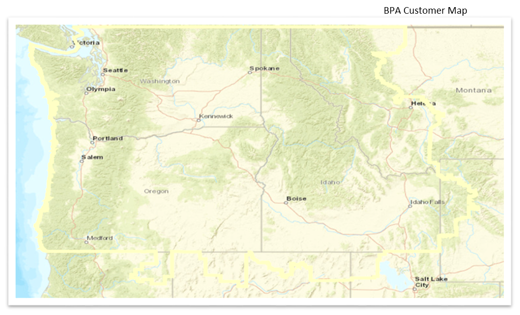
BPA customer map
Users should keep in mind the legal disclaimers that come with the BPA customer map, but it provides the best available information on what’s in and what’s out under the Washington EIA.
Even this complicated “Pacific Northwest” definition has exceptions
A further challenge in sorting out geographic eligibility is that in some cases, the “Pacific Northwest” boundary does not actually matter. These exceptions are:
Hydroelectric facilities in pipes and canals – The geographic eligibility of these projects is restricted to facilities in Washington.
Multi-state utilities – A utility that operates in states other than Washington may use renewable resources in another state where it has customers. For example, PacifiCorp has used wind energy from Wyoming projects that are located outside the Pacific Northwest boundary. This provision does not apply to hydro facilities, and the utility must own or have a long-term purchased power contract for the renewable resource.
Power delivered into Washington on a real-time basis – The geographic boundary does not apply if the electricity is “delivered into Washington state on a real-time basis without shaping, storage, or integration services.” This provision does not apply to hydro facilities.
The real-time delivery exception is pretty arcane, and the EIA statute does not define any of the terms used there. However, Commerce issued an advisory opinion in 2016 that ties this provision to the techniques electric utilities use to manage the electric power transmission system. It provides an approach that a project owner and a Washington utility could use to qualify an out-of-region resource under the EIA. A recent study by BPA and its partners concluded that by using this approach, developers could likely build wind projects in eastern Montana and eligible real-time deliveries of the electricity into Washington that would be eligible under the Washington EIA.
A more straightforward definition would be helpful
The BPA map is a helpful resource, but even better would be a less complicated definition. The definition is opaque to the companies that develop new renewable energy projects, and even the staff at Washington utilities often need help in figuring out what is eligible and what is not. It is too easy to reach an incorrect conclusion about whether a resource in California, Utah, Nevada, Wyoming or Montana is eligible.
It also is hard to see any public purpose being served by having such a complex geographic boundary. The limit on geographic eligibility is meant to support the development of renewable resource that are reasonably close to Washington’s customers. That purpose could be served with a simple boundary based on state lines. For example, the geographic eligibility boundary could include the entire states of Washington, Oregon, Idaho and Montana. This would remove the small slices of Nevada, Utah, California, and Wyoming while adding the eastern side of Montana.